

By Noushin Ziafati
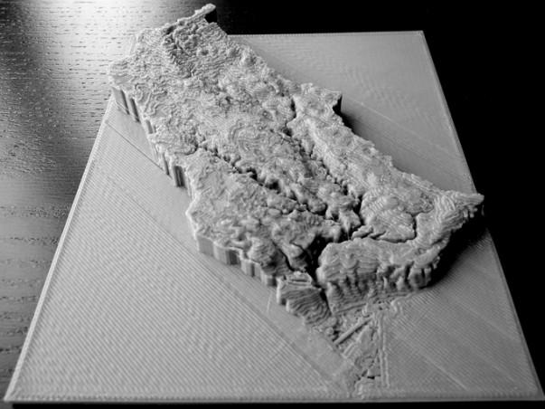
The Don River ebbs and flows throughout its 38 k.m. length across the Greater Toronto Area (GTA), but in a classroom it’s the size of a textbook.
To show the massive scale of this body of water, among others across the GTA, two Ryerson professors are printing 3D models of every watershed, which are bodies of water, to teach high school students about urban water.
Geography professor Claire Oswald is collaborating with professor and chair of geography and environmental studies Claus Rinner and Ryerson-affiliated 3D printing company Think2Thing to create these watershed models.
Oswald and Rinner received funding last spring from Ryerson’s RECODE, an initiative based around working with university businesses. Once their proposal for the 3D printing project got approved, they started building models and creating a teaching plan for the year-long project.
“The reason that we’ve been doing these 3D printings is that we think that they might be really useful for helping people understand … some issues that our watersheds are having and also to point out some environmental stewardship opportunities,” Oswald said.
After finishing a 3D printing course at the Toronto Reference Library, Oswald and Rinner used the library’s Digital Innovation Hub printer to print out their first model, which is the 3D elevation model of the Don River watershed. The model is made out of a renewable and biodegradable plastic.
So far, the two have printed all of the Toronto and Region Conservation Authority’s watersheds.
Undergraduate students in the Geographic Analysis and Environment and Urban Sustainability programs are taking part in the project as well. They’re collecting data for the 3D print models and creating content that they will take to some high schools this term.
Matthew Tam, a third-year geographic analysis student, is involved in data collection and analysis for the watershed model prints. He believes that showing students 3D models of watersheds is an effective tool.
“I think as high schoolers, they want to see something real like a model … instead of reading [about a watershed] from a textbook. It’s more interactive. They can actually see it, touch it in person,” Tam said.
Similarly, Rinner said that viewing a 3D elevation model that is able to illustrate the different processes of water, particularly in urban watersheds, is a new way to teach students about water.
Sarah Brigel, a fourth-year environmental and urban sustainability student, said that the content for this project which her and four group members are working on is designed to focus on the students’ local area and allow them to create a personal connection to their local watershed.
“We think that this is a really important opportunity to not only engage students at a younger age and maybe give them a possibility or a direction into university but also, just to show students that at any age, they can be stewards of their environment,” she said.
Oswald is also a member of Ryerson Urban Water (RUW), which is a multi-disciplinary collective of researchers and experts who aim to support a healthy urban water cycle while promoting new ways to teach students about water. Angela Murphy, the manager of Ryerson Urban Water, is also supportive of Oswald and Rinner’s project.
“Most of the RUW folks that have bridged out to different schools have done so in very illustrative, practical ways,” said Murphy. “If there is a pond or a creek behind the school, that’s kind of the focal point where they begin the discussion and in other cases, they take things with them like watershed models, and that’s where the example of a 3D model was very useful.”
Rinner and Oswald are currently working on a larger, higher quality reprint of the Don River watershed with Think2Thing’s printers, which will feature colour overlay on the print to distinguish different land uses by colour.


Leave a Reply